FAQs
Getting started
| Expand | ||
|---|---|---|
| ||
As an administrator of an organization, you can configure your LocalMaps Gallery to showcase the geographic information that's important to the organization. The main gallery content displayed comes from a Group that is set up in ArcGIS Online or Portal for ArcGIS, depending on which system your LocalMaps is set up against. This group will need to be created first before any content can be made accessible to the gallery. See here on how to create a group. Next, ensure that your newly created group is set as the LocalMaps Group in the application settings page. For information on how the set the LocalMaps Group see General Settings Then, to add a web map to the LocalMaps gallery you will need to share it to the LocalMaps Group. See here on how to share items to a group ArcGIS online or Portal for ArcGIS. |
| Expand | ||
|---|---|---|
| ||
Categories in LocalMaps are based on the item tags you create in ArcGIS Online or Portal for ArcGIS. What this means is that for a Map to appear in a Category you set, the item in ArcGIS Online or Portal for ArcGIS must also have that Category name entered as a Tag. For more information on how to configure Tags see Esri Item Details help. To set up, order or delete a category in LocalMaps see the Categories help page. |
| Expand | ||
|---|---|---|
| ||
With LocalMaps, you can also provide access to restricted maps and content if necessary. This is particularly useful for internal staff or contractors that may want to use the LocalMaps Gallery as a central destination to access content from your organisation. To make secure maps available in the LocalMaps gallery, complete the following steps.
|
| Expand | ||
|---|---|---|
| ||
LocalMaps supports all Esri Standard Authentication methods such as Built in Users, SAML and Web-Tier Authentication (IWA). To leverage these methods, we assume they will have been set up by your organisation prior to LocalMaps installation. For more information, please see the Authentication section. |
General Questions
| Expand | ||
|---|---|---|
| ||
The following are saved:
The following are those not saved:
|
| Expand | ||
|---|---|---|
| ||
We do not currently support the use of custom elevation services in the elevation profile tool. |
| Expand | ||
|---|---|---|
| ||
The LocalMaps codebase is covered by the Eagle Standard Support Policy. https://www.eagle.co.nz/gis-support-policy. This means that any issues outside the standard configuration (including customizations or alterations made by the customer) will not be supported. |
| Expand | ||
|---|---|---|
| ||
Within LocalMaps, the search results are usually ordered by Object ID. This usually causes issues when searching for a feature that comes first alphabetically, but comes last when ordered by Object ID. So, in version 2.3.1 we introduced the option to change this and set the searches to sort alphabetically. This is not done in the front end administration tools and does require accessing the LocalMaps Database. If you require advice, please contact Eagle Support. To enable this:
|
| Expand | ||
|---|---|---|
| ||
Yes you can! You will need access to the web server that hosts LocalMaps though. Please contact LocalMaps Support if you need advice on this. To use your own Icon you need to ensure you save this as a flavicon. Then, simply go to the LocalMaps Gallery folder, and copy in your.ico file. 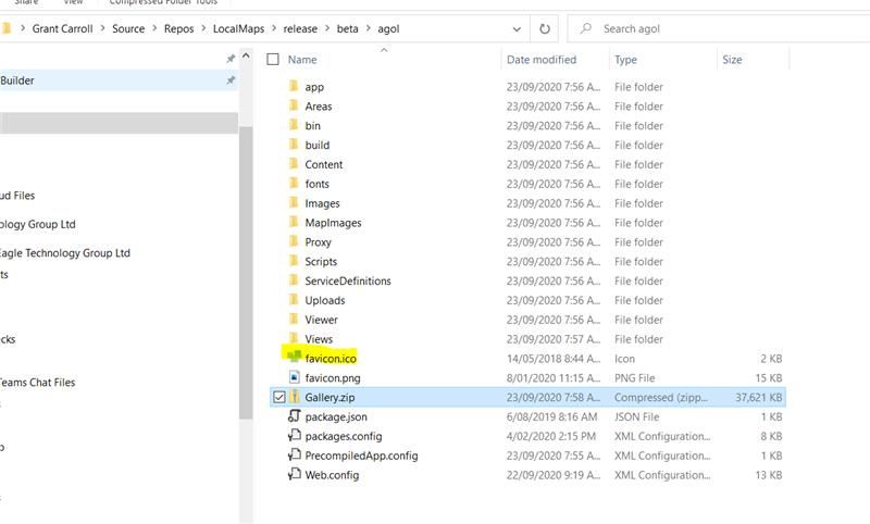 |
| Expand | ||
|---|---|---|
| ||
If you create labels within the web map within the Map Viewer in Enterprise or ArcGIS Online, we cannot support those in the LocalMaps reporting. If the layers are on the service or if they have a separate service just for labels we can support that. This is because when you create the labels in the web map, they are created as a graphics layer in the map. So each time a pan and zoom is made the labels are dynamically drawn on the map only for the extent that you are viewing. When you send the web map to the print service, a snapshot of the label graphics are sent to the print task in the ExportWebMap JSON which the print service processes. Because when we create a report we are using the ExportWebMap JSON we don't have sufficient detail in the ExportWebMap JSON to get the required labels from the all the layers in the extent and then add them to the ExportWebMap before we send to the Print Service. |
| Expand | ||
|---|---|---|
| ||
Yes you can! You will need access to the web server that hosts LocalMaps though. Please contact LocalMaps Support if you need advice on this. To set the default value for printing, you can change that in the print.html file in the print widget folder. See here. Search for nls.dpi in the file and you should find it pretty quick. Set the value to 150 rather than 96 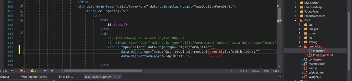 |
| Expand | ||
|---|---|---|
| ||
Yes, if you are using LocalMaps v2.3.1. Within the settings page, there is an option to Enable Automatic Login. By default, this will be set to no. Change it to yes and then clear your cache. Users should now be presented with the LocalMaps Login screen when they go to the URL.  |
| Expand | ||
|---|---|---|
| ||
The Report buffer function is designed to only buffer Map elements in reports. Any table or conditional text elements will not returned the buffered results unless you set a buffer for that specific element. |
| Expand | ||
|---|---|---|
| ||
This is more an FYI for folks out there. Take caution when changing the print service for your LocalMaps as this will have affect over various elements throughout the tool. Reports may be affected as they utilize the print service as well. You may experience some strange behaviour if you do choose to change it and must clear your cache to have the update applied. It may also take a bit of time to save a print service change so if you find it not updating in a reasonable time frame a workaround is to just refresh the page. You should see that the updated service has been saved. |
| Expand | ||
|---|---|---|
| ||
Hidden sites will be updated on the layer after your next IoT layer refresh interval i.e. if you set it for 24hrs, the hidden site will be removed from view by the next day. |
| Expand | ||
|---|---|---|
| ||
This may occur if you are using a point layer as points cannot contain features therefore that choice of relationship doesn't work. We suggest changing to another relationships type. For more detailed information on spatial relationships that can be validated see here: https://desktop.arcgis.com/en/arcmap/latest/extensions/data-reviewer/types-of-spatial-relationships-that-can-be-validated.htm |
| Expand | ||
|---|---|---|
| ||
This might be occurring because the layers in question have scale dependencies set. This means that when you configure that Map in your report, the map preview may not be showing those layers at the scale they need to be at to display. To fix this issue, go to the map element in your report and simply zoom in to the desired scale to display those layers. Hit save and the layers should now be displaying the generate report. |
| Expand | ||
|---|---|---|
| ||
The gallery timeout period correlates to your ArcGIS Portal / ArcGIS Online timeout e.g., if your ArcGIS Portal / ArcGIS Online timeout is set to 12hrs, then LocalMaps ill timeout after 12hours of inactivity. |
| Expand | ||
|---|---|---|
| ||
To filter data you use the select widget and select by attributes. (Filtering cannot be done through the attributes table and will be addressed in next release.) |
Known Issues & Troubleshooting
Map Configuration
| Expand | ||
|---|---|---|
| ||
Sometimes LocalMaps needs the Print widget to be activated in the admin to pull in the print layouts and templates for that map. If they are blank when you open the widget in the viewer then you just need to login into the Admin, go to the Maps & Apps section and for each map, disable and re-enable a print template to pull in the configurations. |
| Expand | ||
|---|---|---|
| ||
Some maps may occasionally have duplicate widgets presented in the maps and apps tab. This was resolved at Version 2.2. It is uncommon to experience this in version release after 2.3. however, if you do see this issue please contact Eagle Support for recommendations. |
General Configuration
| Expand | ||
|---|---|---|
| ||
This has been addressed in the LocalMaps 2.3.1 Quality patch. For those with older versions, our suggestion is to upgrade to the latest version. |
| Expand | ||
|---|---|---|
| ||
For a layer to be used to base a report from or run a feature query against it must be 1) in the map you are trying to assign it to and 2) registered as a datasource in LocalMaps. |
| Expand | ||
|---|---|---|
| ||
If you update the Gallery styles and they do not come through when you refresh the gallery, just try clearing your browser cache and refreshing again. |
| Expand | ||
|---|---|---|
| ||
If you have a service registered as a datasource and you would like to delete it, there are a couple of extra steps that act as a safety mechanism. These were implemented to prevent users from accidentally deleting a service that was used throughout LocalMaps! |
| Expand | ||
|---|---|---|
| ||
Check if you have basemaps from different projections in your Basemaps group or set for the organisation. If so, then the basemap widget does not support this, |
| Expand | ||
|---|---|---|
| ||
Reports that have a maps as the last element may have a blank page at the end of the report once generate. This is a known issue as was addressed in the LocalMaps 2.3.1 Patch. If you do not have this version, a suggested workaround may be to change the order of the elements to have one other than a map last. Alternatively, you could add in an empty text element as your last report item. |
| Expand | ||
|---|---|---|
| ||
If you create a report table without assigning a Layer or Database query, you may experience an error message "Cannot find property 'queryName' of undefined", preventing the user from configuring report elements. If you are experiencing this, please contact Eagle support who will be able to advise. |
| Expand | ||
|---|---|---|
| ||
Edit the query, re-save the table then exit the table window and go back in to check the selected fields are available in the drop-down. |
| Expand | ||
|---|---|---|
| ||
You will not able able to upload feature images through the Admin if you are using LocalMaps with Integrated Windows Authentication (IWA). The workaround for this is to:
|
Gallery
| Expand | ||
|---|---|---|
| ||
Extra content that comes into LocalMaps when logged in is defined by a “search tag” in the LocalMaps Database. By default, this should be set to “LocalMaps” and therefore any items in your ArcGIS Online or Portal that have the tag “LocalMaps” will come into the Gallery when logged in. These do not have to be in the LocalMaps Group itself. Sometimes, the Search Tag that is set, is not correct and therefore the gallery will pull in these extra items that you do not want. To fix this:
|
| Expand | ||
|---|---|---|
| ||
There is a known issue in LocalMaps, where if you are in the LocalMaps Gallery and resize the browser window, the font colour of the Web Map name and description changes to white. This may happen regardless of the colour set in the Admin > Gallery. We are aware of this issue and will address in the next version. |
| Expand | ||
|---|---|---|
| ||
When creating new links or deleting existing links for footers in the gallery the gallery should be refreshed to see the result. This does not apply when modifying. |
| Expand | ||
|---|---|---|
| ||
This is a known issue in 2.3.1 and 2.3.2 sites. The UI will appear to show two layers ticked on when you are setting the relationship for your Feature Query. Don’t worry - the one you selected is actually the only one selected. The other is not selected or being edited in any way.  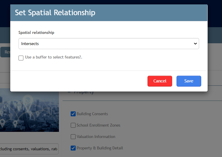 |
Viewer
| Expand | ||
|---|---|---|
| ||
There are a few things to check if this occurs as it could be any one of these.
|
| Expand | ||
|---|---|---|
| ||
If your organisation uses your own basemaps in LocalMaps, the upgrade process may override this and covert the group the basemap widget is looking at back to the ArcGIS Online basemaps. The result of this is that you may get a series of basemap thumbnails but with broken image links. This should be resolved in the LocalMaps 2.3.1 Patch. If you do not have this version, try change the basemap group in the settings tab and then change it back to the original basemap group. |
| Expand | ||
|---|---|---|
| ||
This could be related to an issue that occurred in Version 2.3 in which if you had not set the LocalMaps Group to a specific group, it did not pull in any basemaps. This is resolved in the LocalMaps 2.3.1 Quality patch. Now if you have not set a group, LocalMaps will automatically pick up your ArcGIS Online or ArcGIS Enterprise Basemap group and set that as your LocalMaps Basemap group. Alternatively, if you are still not seeing any basemaps just check that they are all using the same projection that the webmap is. This is a standard limitation of the Esri Basemap Gallery widget alongside the following unsupported workflows:
Best practice recommendations are as follows:
|
| Expand | ||
|---|---|---|
| ||
This is a known issue in the Draw / Measure tool where if you move a graphic with measurements, the final length will have an additional measurement added (a very small figure). If will only occur when the graphic is moved from its original position. If you come across this problem, our suggestion is to re-draw the graphic in the desired location. |
| Expand | ||
|---|---|---|
| ||
This is a known issue in the Draw / Measure tool on Tablet devices. This will not be resolved in version 2.3.1. |
| Expand | ||
|---|---|---|
| ||
This has been seen to occur sometimes when organisations are moving from v2.3 to 2.3.1. It is suspected to occur because the print task / layout has been changed in version 2.3 one or more times and then the site was upgraded to 2.3.1. This sometimes causes the layouts and templates to duplicate. There is a simple fix for this so just contact Eagle for more information and assistance on how to remove them. |
| Expand | ||
|---|---|---|
| ||
This is a known issue that may occur in LocalMaps Version 2.3.1. If you are experiencing this, please contact Eagle and we can easily provide a solution that will resolve the issue and show the correct bearing and segmented length measurements on polyline graphics. |
| Expand | ||
|---|---|---|
| ||
If you lose access to maps in the switch map widget when opening a bookmarked map, it is possibly because you have logged in through the viewer. To avoid this issue, make sure you login in through the gallery before opening the map. |
| Expand | ||
|---|---|---|
| ||
When printing using the print widget make sure the print preview frame is visible in the map extent to ensure that all the information is included in the print this is especially important when working with vector tile layers. |
Reporting
| Expand | ||
|---|---|---|
| ||
The use of Vector Basemaps in reports is supported in v2.3.1. However, if you are on this version or recently upgraded to 2.3.1 and still cannot see them then try resaving your existing webmaps that contain the Vector basemap. This allows LocalMaps to rewrite the JSON that forms the map so that it now knows your have that type of basemap in there. Please note that Vector Basemaps are only supported if you are using a print service generated from ArcGIS Pro. |
| Expand | ||
|---|---|---|
| ||
This is an intermittent issue but we have found that setting a defined “Degree of Parallelism” for the reporting helps to alleviate the issues with some components dropping out of LocalMaps Report. The degree of parallelism (DOP) determines how many map elements can be generated concurrently when a report is run. This should ideally match the number of cores the machine has that is hosting the LocalMaps applications. E.g. 4 cores = 4 DOP. If you are experiencing this issue, please contact Eagle GIS Support and we can advise how to set the DOP to best suit your machine specs. |
| Expand | ||
|---|---|---|
| ||
A small selection of sites have experienced issues generating reports that contain spatial queries created in LocalMaps versions prior to 2.3.1. This is due to updates made around our support for different spatial references. This can be easily resolved by updating the LatestWKID and the WKID fields to the correct spatial reference in the ARCGISServerService table of the LocalMaps Database. Please contact GISsupport@eagle.co.nz to have this implemented if needed. |
| Expand | ||
|---|---|---|
| ||
Prior to version 2.3.2 the Esri Imagery Hybrid basemap would not always show in report maps. As of version 2.3.2, imagery will now show, however reference information is not shown on top and if you run a report based on a projection different to the basemap the feature will not be shown in the right location (NZTM features will probably be displayed in the middle of the sea somewhere). |
Groups & Sharing
| Expand | ||
|---|---|---|
| ||
LocalMaps is designed to bring back and present the first 100 groups in your Organization in the LocalMaps Settings. If you have more than 100 groups, LocalMaps will not display the most recently created. This is a known limitation and our recommendation would to be to review your current groups and reduce the count. |
Searching
| Expand | ||
|---|---|---|
| ||
This issue has been known to occur when you have have the same service used in multiple searches. For instance, one map service might contain multiple sublayers - Property, Roads, Addresses, Parcels etc and each time you create a search, you only want to search against one of those sublayers. We do not recommend this approach as you may have mixed results when using the search. We suggest (if you can) using specific search services for searching against. This will remove not only this known limitation but also increase speed, performance and overall experience for your end users. |
| Expand | ||
|---|---|---|
| ||
This is a known issue that may occur in LocalMaps Version 2.3.1. If you are experiencing this, please contact Eagle and we can easily provide a solution that will resolve the issue and allow for searches to run without opening a popup. |
| Expand | ||
|---|---|---|
| ||
When using the search bar in the map a list of suggestion will appear. Make sure to select a suggestion rather than hitting enter as this may cause the map to zoom to a location from the suggestion that may not necessarily be the one you wanted. |
Installation
| Expand | ||
|---|---|---|
| ||
In some instances after LocalMaps Upgrades or fresh installs the print task was not being pushed into the app configuration file correctly. So when the widget was fired up it could not reach the service URL. This is resolved in the LocalMaps 2.3.1 Quality patch. If you have an older version of LocalMaps please try hitting the “reset Viewer” button in the Admin settings page.and then clearing your browser cache. If that does not solve the issue, contact Eagle an alternative solution which will require checking some of the app files. |