Skip to end of metadata
Go to start of metadata

You are viewing an old version of this content. View the current version.

Compare with Current View Version History

« Previous Version 8 Next »

Road Assessment and Maintenance Management (RAMM) are a suite of applications to maintain and manage Road Asset data. RAMM software is used widely across New Zealand by NZ Road Controlling Authorities (RCAs) i.e. Councils and NZTA, engineering consultants and road maintenance contracting companies. RAMM functions include Asset maintenance, Asset valuation, Asset assessment, Forward Work Planning, Inventory based Asset management.

LocalMaps ____ engine simplifies how you can bring roading data into ArcGIS by allowing you to generate a hosted feature layer that pulls data directly from an existing RAMM Service URL.

This section will walk you through building a RAMM hosted Feature layer that sits in your ArcGIS Online or Portal for ArcGIS Organisation. By simply, imputing a RAMM Service URL you have the option to then define specific attributes to pull through and change alias fields to make a more readable output for users. You can then synchronize your layer to bring in any adds, deletes or updates on a scheduled basis. 

Although the RAMM Layer is created through LocalMaps, its usage can go well beyond just the LocalMaps application. Accessible to the entire ArcGIS Platform, RAMM layer then be consumed in any web map, web application or in Desktop apps like ArcGIS Pro. 

LICENSING INFO

Need Help?

Email LocalMaps Support to ask a question or request assistance.

Configure RAMM Layer

  1. To create a new RAMM Layer, click New
  2. Enter a RAMM Service name for the so you can identify it later.
  3. Enter the RAMM Service URL including any parameters. Click Continue

Click to enlarge image

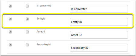
4. Next you can select the fields that you would like brought through in to the RAMM Feature Service. Here, you can also give them an alias, so instead of displaying road_id we can show Road IdAn important note here is that you must keep the OBJECT ID and GLOBALID as these are required by Esri.

Click to enlarge image

5. You must also select one and only one identifier field, it is suggested you use "Entity ID", this issued to keep track of what features we have loaded and what may be new.

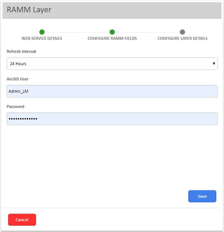
6. Next, define a desired Refresh Interval for your Layer. Options are 24 hours, 48 hours, 36 hours or 72 hours. 

7. Enter your admin username and password for your ArcGIS Online or Portal organisation and then Save to create the RAMM layer.


View Layer


Edit / Delete Layer

  • No labels